The full study can be accessed: Here
The City of Waterloo was looking to improve their bike infrastructure through a 3-year program, which requires the development of a bikeability index to assess how bike-friendly areas of the city are, and examine other areas which require improvements. The City of Waterloo requires that this solution is replicable, and have the ability to be transferred between different departments easily. The problem that this report examines, is the development of a method to asses bikeability, the data requirements and areas of improvement for this data, alternative GIS platforms, along with a project plan including timelines, project staff, budgets, future of the project after completion, and any staff training. The solution that we developed is focused around examining six separate features and how they contribute to the bikeability of the city through raster calculations to develop a continuous bikeability index surface.
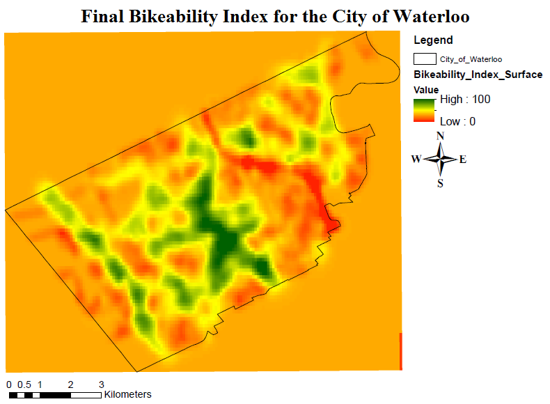
The Final Bikeability Index for the City of Waterloo map features the weighted sums of the six raster files shown above. This provides us with quite a few observations about the bikeability of the City of Waterloo. The first of these is that Waterloo is already a very bike-friendly city, as you can see, there are very large areas in the city with high bikeability cell values. These are primarily centered around the middle of Waterloo, close to Wilfrid Laurier University, the University of Waterloo, and Uptown Waterloo, along with other areas such as Conestoga Mall, and Erbsville Road. The map also highlights areas for improvement, mainly centered around residential areas that lack the same protections that main streets have. This is especially present around the Conestoga Parkway, where a large amount of the map has a bikeability index of less than 50. The Conestoga Parkway presents an interesting problem to bike infrastructure as well, and this issue is highlighted in our map. Currently, there are very few safe methods for cyclists to travel from one side of Conestoga Parkway to the other, with the safest routes being found near Conestoga mall by taking public transportation.
With such a stark division within the City of Waterloo, it is important to address these issues heading forward as the city expands.