Last Modified: April 16, 2021
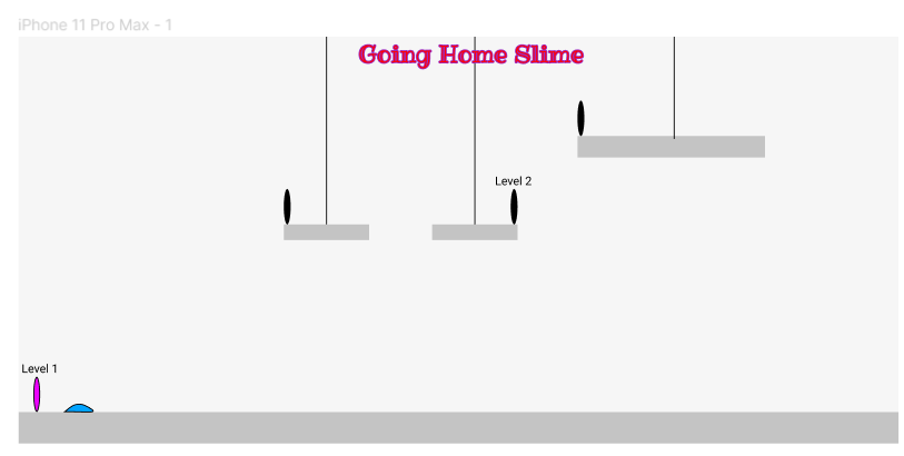
The game is about a slime that is lost and is trying to get back to its home. The slime needs to go through various maps and solve many puzzles in order to reach its destination. The game was built for fun in game design course. The name was chosen as a modification of Slime - Smile -- S[li]m[il]e. Although incomplete, Mid-Fidelity prototype can be played:
Last Modified: April 6, 2018
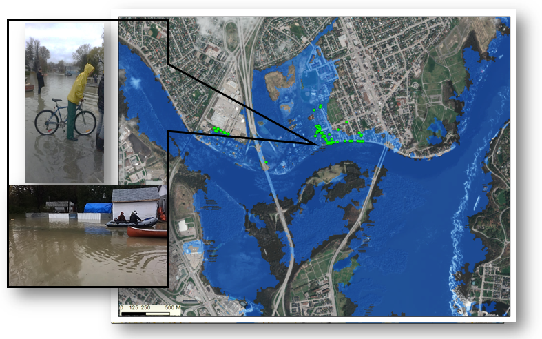
This study examines the applicability of using remote sensing data and techniques in order to determine the extent of the damage the Ottawa River flood can incur on the surrounding landscapes, as well as the economic damage of buildings within the flood extent. This project aims to explore urban area land use change and their potential impacts on not only the hydrology of the area, but also the degree of impact of these changes on flood events. In determining the impact of land use change and its spatial relation to the river in terms of river flooding, as well as determining the economic flood damages that occur due to it, this project aims to not only create a workflow in determining economic damage per land use change, but also examine future techniques of determining flood mitigation techniques in the city of Ottawa and all other communities within the floodplain of the Ottawa River.
Last Modified: April 9, 2018
With the increase in global warming and global temperature, there has been an increase in natural hazards. Scientists have estimated, with an increase in global temperature, there will be an increase in extreme weather events and natural hazards. These changes will affect almost all parts of the world, and the Caribbean islands are especially in danger because of their isolation. One of the island which is prone to natural hazards is Grenada. This study was conducted to determine the overall hazard risk of Grenada.
Last Modified: December 4, 2020
This is a Local Area Network Office Messaging System created using Java. The video above shows a demonstration of the application, and the development process. It is created using the software development life cycle, and it uses Model View Controller design pattern.
Last Modified: April 4, 2021
Sound warning!
A 3D maze created using threejs. Although it is a maze, collision has yet not been implemented. Showcases lighting effect, movement, and 3D FPS view using threejs.
W,A,S,D or arrow keys to move!
Last Modified: April 15, 2021
Sound warning!
Real estate home design fully constructed using blender, and displayed in threejs. Implements lighting effects, shading, and shadows.
Any home can be designed and displayed in threejs fairly quickly using a floor plan and modelling in blender/sketchup; then importing into threejs for a custom 3D display of the home. This method of creation and implementation can be used for modelling and displaying any object in the web.
A detailed guide on constructing an object in blender/sketchup and importing into threejs for a custom 3D view will be added here soon!
Last Modified: April 3, 2017
This project is based on the premise of streamlining the collection and organization of twitter data for analysis through the use of various tools. Twitter data mentioning trump positively and negatively, regards to wall, health care and immigration was used for visualization and analysis purposes. A python application for extracting twitter data was created, and the tweets are displayed in a leaflet map.
Last Modified: April 1, 2017
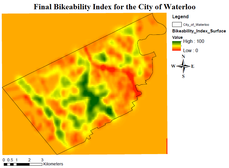
This project looks at the bikeability within waterloo region, as well as a solution to various problems such as: developing a method to asses bikeability, the data requirements and areas of improvement for this data, alternative GIS platforms, along with a project plan including timelines, project staff, budgets, future of the project after completion, and any staff training. The solution that we developed is focused around examining six separate features and how they contribute to the bikeability of the city through raster calculations to develop a continuous bikeability index surface. The final result can be seen in the image above.
Last Modified: Feburary 1, 2017
This project had two major components: data collection, and data display. The data of various sidewalk hazard were gathered using Arc Collector. This data was then saved as GeoJSON and displayed using Leaflet and ESRI Javascript API. Afterwards, the functionality of Leaflet and ESRI Javascript API were evaluated. Lastly, this hazard information was presented to Waterloo Municipality to be fixed.
Last Modified: May 16, 2016
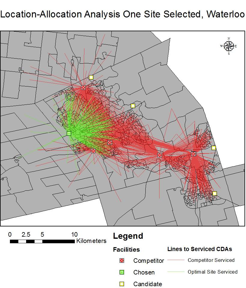
This project was conducted to find an optimal location for constructing a new Lowe's Store within the Waterloo region. Choosing where to build a new retail location is a challenging task for any business since there are many factors that need to be considered before a location is selected. Some of these factors include: competing locations, transportation networks and the demand for products in an area. Predicting which customers will shop at the new location is vital to choosing the correct site location. The final result on the most economical location to construct a new store can be seen in the image above.
Last Modified: June 1, 2016
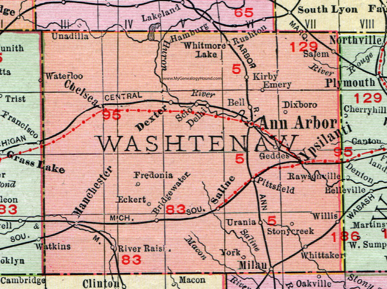
For a city to expand, neighboring areas must be developed in order to grow the city limits. However, land is a precious resource and should be allocated appropriately. If land is developed upon randomly, there can be grave consequences; such as erosion damaging building foundations or agricultural land unable to grow crops. Therefore careful planning is a requirement for the successful expansion of a city. This project was conducted to determine suitability regions for future development in Northeastern Washtenaw County, Michigan.